The National Directorate for Fire and Emergency Management held an online meeting ahead of Storm Dudley (tomorrow) and Storm Eunice (Friday).
Met Éireann, the OPW, local authorities, and other responding agencies attended ahead of Storm Dudley's arrival.
The team is going to continue to engage with Met Éireann to keep an eye on an "evolving situation" to see if any more meetings are needed.
Weather Warnings
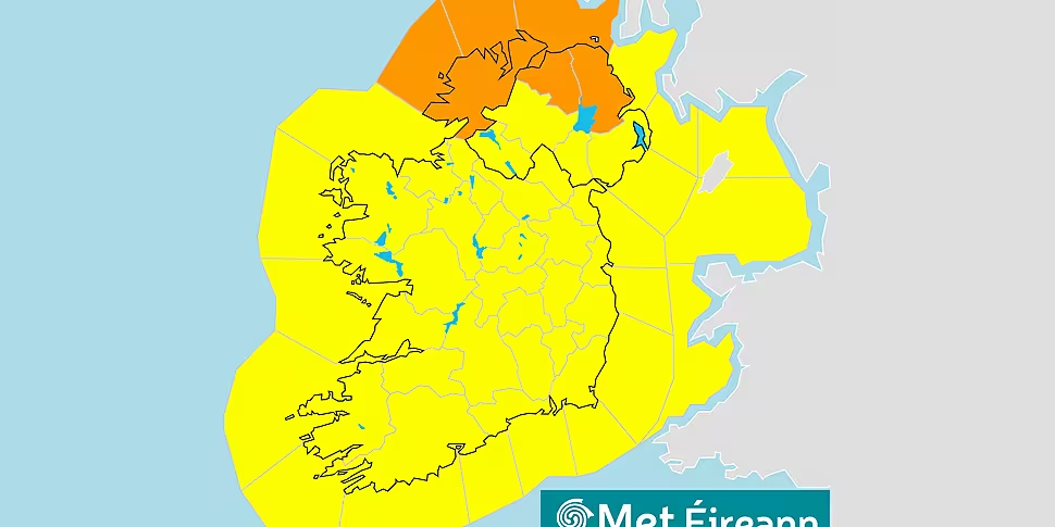
Met Éireann has issued an Orange Wind Warning for Donegal and a Yellow one for the rest of Ireland ahead of Storm Dudley.
Donegal will experience "damaging" winds, gusting up to 130 kilometres per hour.
The orange warning comes into force at 9pm Wednesday until 9am Thursday.
Donegal is also covered by the yellow warning (see below!) before the orange one begins.
They could even get stronger on exposed coasts and on high ground.
🔶Orange🔶
📍Donegal
🌬Westerly winds associated with #StormDudley will reach mean speeds of 65 – 80km/h with damaging gusts of 100 – 130km/h, stronger on exposed coasts and on high ground.
🌊Some coastal flooding likely.
📆Wed16 - Thurs 17 Feb
⌚9pm- 9am pic.twitter.com/b8Yw3E3et6— RSA Ireland (@RSAIreland) February 14, 2022
Yellow Warning
Meanwhile, the rest of the country won't get the very worst Dudley has to offer, but the yellow warning's coming into effect at midday tomorrow.
It will expire at Midday on Thursday.
There's more information at this link.
Key Public Safety Messages:
General Public safety advice from the Emergency Group:
- Stay away from all coastal areas for the duration of the Met Éireann warnings.
- All road users should be aware of the potential for hazardous travelling conditions.
- Motorists should slow down and be aware of the dangers of fallen trees and debris.
- High sided vehicles, cyclists and motorcyclists are particularly vulnerable during this time.
- Keep mobile phone charged.It is critical that people never ever touch or approach fallen wires.
- Stay safe and stay clear of fallen or damage electricity wires, and contact ESB Networks on 1800 372 999.


